Farmstead clusters on the Don
If you look hard enough, you will find that most atlas elements have their own own spatial logic. One of the striking examples of this is the farmsteads layer. The active map below is a window on to the Imperiia Map. The only layer toggled on is the farmsteads layer. Take a moment to pan and zoom around and get a sense of the raw distribution of farmsteads.
Note: You can use the green folder icon to toggle layers on/off, though I recommend going directly to the Imperiia Map to do that. Also, the individual features are not clickable via this embed; again, go straight to the Imperiia Map itself for full functionality.
Panning and zooming makes the geospatial distribution of farmsteads quite clear, but just for good measure we can map the number of farmsteads per administrative unit.

It turns out that 98 out of 228 total farmsteads (43%) are located in the Don Cossack territory and another 40 (18%) are located in adjacent provinces. A thought-provoking statistic, indeed.
It is just as interesting to look at the other end of the spectrum - at the provinces with a lone farmstead. Provinces such as Irkutsk and Orenburg, which stand so far afield in Siberia; or Mogilev and Smolensk, which sit on the outer fringe of the cluster area. And what do we make of the fact that the Grand Duchy of Finland, Bessarabia, and Lifliand contain two farmsteads apiece?
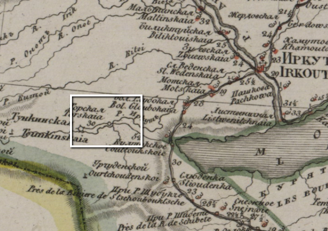
Perhaps we have hit on a misreading of the atlas symbology? Let's look at the single khutor location in Irkustsk:
And while we are at it, here are the two supposed khutors in Bessarabia:
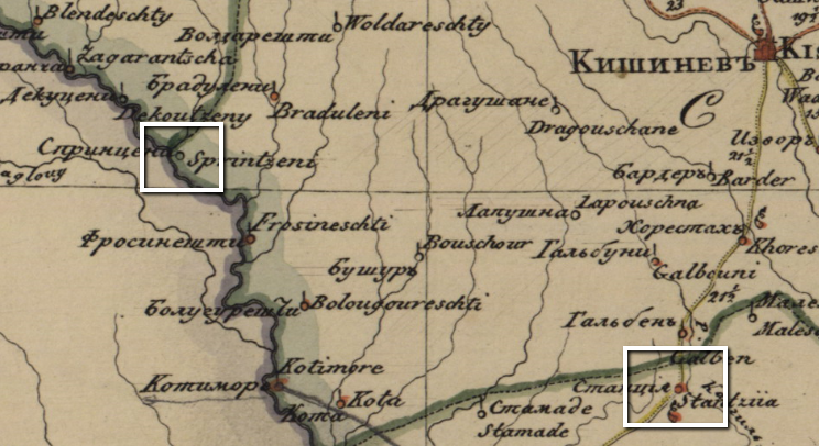
The telltale unadorned circular symbols are there, clear as day. But neither the Irkutsk sheet legend nor the Bessarabia sheet legend includes the symbol (the same holds for the other provinces).
What we have then, is a classic case of the educated guess. Based on the fact that the undorned circular symbol is defined on other sheets as the symbol of a farmstead and is never used as the symbol of any other kind of site, our guess is that the symbology holds throughout the atlas. It is an educated guess (and one that stays true to the atlas itself), but a guess nonetheless.
So, what can we learn about farmsteads from their geographical distribution? What was it about the Don Cossack lands that made it the farmsteading heartland of the empire? And what do we make of those ambiguous circles sprinkled in distant corners of the empire? Do they attest to the presence of farmsteads, or of other undefined elements of the empire's spatial profile?