The lost lake of Alaktugul'
In the age of GPS and satellite imagery we have grown understandably confident in the idea that we know where everything is and what it looks like. How much did His Majesty's General Staff know, in the 1820s, of an empire that extended across two continents? To what extent can we consider the Geographical Atlas of the Russian Empire "accurate"? And is it uniformly accurate? Or does it grow less reliable the further one moves from Moscow and St. Petersburg?
Generally speaking the Piadyshev atlas is accurate indeed: the fact that the georeferenced mosaic constructed of the original atlas is off by only 3-5 kilometers across most of imperial space attests to the talents of the cartographers of the Cartographic Depot of the General Staff (as well as to those of the GIS specialists who digitized the atlas). Its accuracy diminishes - quite strikingly in some cases - along the coasts, but the empire's lakes and rivers were clearly of primary interest.
To have produced good maps of Lake Ladoga or Lake Onega was one thing. The elaborate filigrees of their coastlines presented a challenge to be sure, but Russians had long since aquired an intimate knowledge of both lakes. Lake Baikal was both less familiar and more remote. Nevertheless, Baikal's signature crescent shape is immediately recognizable on the Irkutsk atlas sheet.

The real frontier of geographic knowledge (and state power) lay west and south of Baikal, in Central Asia. Russian power had been seeping into the region since the late sixteenth century, but it wasn't until 1716 that Russian forces built a fortress at what would come to be known as Omsk. At the beginning of the nineteenth century, Omsk became the administrative center (read more on Omsk and the administrative geogrpahy of Siberia) of a province that stretched roughly 1,100 kilometers to Lake Balkhash.
Here is where things get interesting. First, let's take these two maps as a rough measure of the relative "distance" of Baikal (left) and Balkhash (right, in yellow box) from the Russian core - however we might define it.
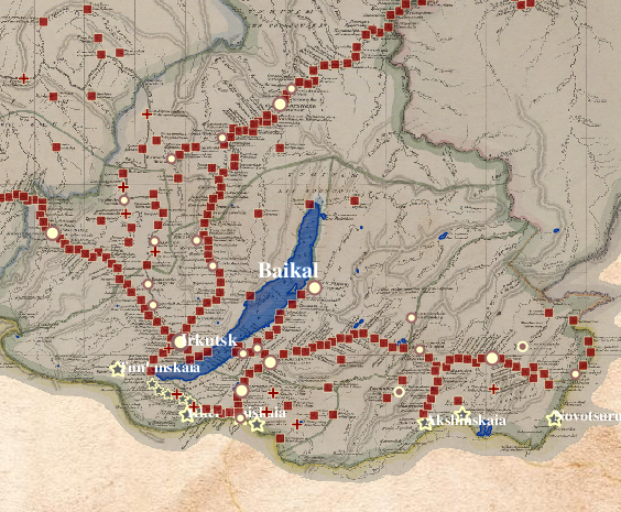
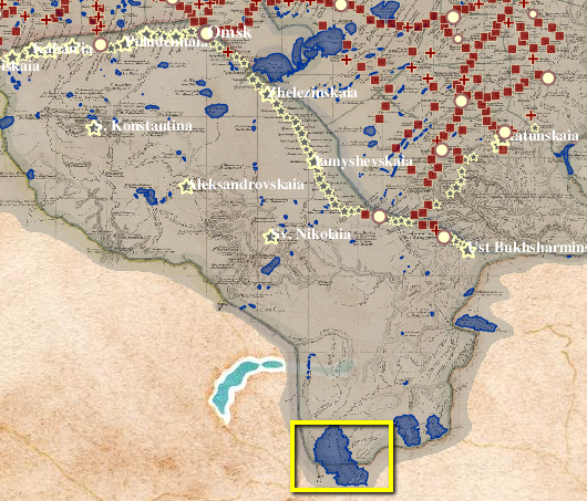
As you can see, Lake Baikal lay on the Siberian equivalent of a thoroughfare. By contrast, Lake Balkhash was 600 kilometers from the nearest (Russian) village.
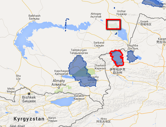
All of this helps to explain the curious presence of two smaller lakes east of Lake Balkhash, just inside the boundary of Omsk province. The lake furthest east is Lake Alakul'. The one in the middle is marked as Lake Alaktugul'.
What is so curious about this trio of lakes?
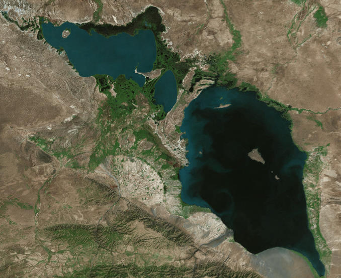
First, let's compare the geometry of Lake Balkhash as presented on the Piadyshev atlas with that of modern satellite imagery (the Google Satellite base map available in the "Base Maps" section at the bottom of the Imperiia map's table of contents).
Clearly, if you are traveling to Lake Balkhash you won't want to rely on the nineteenth-century atlas, which seems to introduce gross distortions to the lake's shape, let alone its location. (There are all sorts of reasons for this: precise astronomical measurements were not taken until the 1830s, for example.)
We seem to get better results with Lake Alakul':
But Lake Alaktugul' is more problematic. Are we to assume that this lake, which Piadyshev and company would have us believe is possibly even larger than Lake Alakul', corresponds to that vague body of water adjacent to the north end of Alakul'?
Perhaps a different base map will help resolve the ambiguity. Let's try Google Terrain:
Or Stamen Toner?
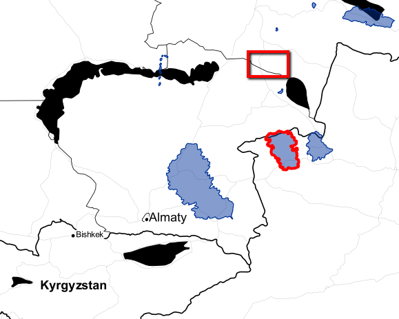
Happily, switching to ESRI's satellite imagery and zooming in does the trick. Now, we can see the two lakes side-by-side:
So Lake Alaktugul' is not lost after all. It might have suffered a serious case of dessication, but it is not lost.
Or is it?
Modern gazetteers such as GeoNames, with its 10 million placenames, make no mention of the Alaktugul'. Moreover, as the ESRI data will tell you, the lake adjacent to, and just (north)west of Alakul', is called Sasykkol', not Alaktugul'.
It is possible that a new toponym replaced the old - regime changes have wrought placename changes all over the world at various times. Such toponymical renovations do not necessarily spread evenly across the landscape. Sometimes a major town receives a new name, while the surrounding smaller settlements remain as they were. But in this case, considering the proximity of the two bodies, it would be odd if Alakul' (or Alakol') retained its name while Alaktugul' did not. Odd, but not impossible.
Still, there is another possibility. What if Lake Alaktugul' never existed?
No less a figure than Baron Alexander von Humboldt posed that very question. In his notes on the lakes of Central Asia published in 1831, von Humboldt devotes a footnote to Lake Alaktugul'. There he notes that local Tatars and Mongols insist that there was but one lake - the Alakul' - the Alaktugul' being nothing more than a figment of imagination or the result of toponymical confusion.
Is Piadyshev trying to pull one over on us? Or was he simply uninformed? If so, how much faith can we put in the Omsk sheet? or in the atlas itself?
Von Humboldt makes another interesting observation. He notes that the authoritative map of Inner Asia published in St. Petersburg by Mr. Pansner (this would be Lavrentij Ivanovich Pansner, a topographer and founder of the Mineralogical Society) showed a series of five narrow channels connecting Alaktugul' to Alakul'. If the channels crossed a marshy isthmus, one that was negligible boundary between the two lakes, that might explain the difference of opinion.
Let's go back to Piadyshev's lakes:
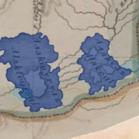
There they are, clear as day: the five narrow channels. Since Pansner's map was published in 1816, it stands to reason that Piadyshev and company used it as a source.
If they had access to the map, that is.
And they did. It just so happened that Lavrentij Pansner worked from 1803 until 1817 in the Cartographic Depot (Депо Карт; reorganized as the Military-Topographic Department in 1812))... where Piadyshev took up a post in 1809. Ah, it is all falling into place now, isn't it? Piadyshev followed Pansner in attesting to the existence of a good-sized lake independent of, though connected to, Alakul'.
In this they were both right and wrong. By the late nineteenth century geographers were sure that in the past the entire region from Balkhash to Alakul' had been a single body of water. When the famous geographer and explorer Nikolaj Mikhailovich Przhevalskiy wrote his "Notices of the Lakes of Central Asia" (translated into English in 1879), he noted that "a belt of desert marked with dessicated lake-beds and sand-waves" stretched for 60 miles west of Lake Alakul. By then there were not two, but three, connected lakes, known collectively as Alakul'.
It is conceivable that the basin had not yet divided into three lakes in the early nineteenth century and that Pansner and Piadyshev had that part right. But for as long as it had existed, the westernmost lake had been known as Sasykkol' (or Sassik-kul), not Alaktugul'.
It was Lake Alakul' itself that bore a former toponym. Two, in fact. It turns out that it had been known in ancient times as Gurgeh-bor, or "lake of bridges", and then more recently by a Kalmyk name - a name that was inscribed on Chinese maps of the region. That name was Alak-tugul(-nor). When the Kirgiz established themselves in the region they endowed the lake with its third name: Alakul.
In other words, Piadyshev's map gets the basic geographical features of the lake more or less right, so far as we can tell. His toponymical error But by presenting two names for the same place - by in a sense pulling apart a toponymical palimpsest - he does indeed introduce a measure of confusion into his map. He also, unwittingly, reminds us of the layered nature of human knowledge the natural world. It is a shifting landscape, and one defined by perspective as much as chronology. And it is a landscape that, every so often, acknowledges its own redundancies, contradictions, myths, and mis-rememberings.
Sources:
von Humboldt, Alexander. "Baron von Humboldt on the Mountains and Volcanos of Central Asia." The Asiatic Journal and Monthly Register for British and Foreign India, China, and Australasia, volume 4 (January-April 1831): 237-238.
Przhevalskij, Nikolaj Mikhailovich. Trans. E. Delmar Morgan. From Kulja, Across the Tien Shan to Lob-Nor (London, 1879): 187-191.